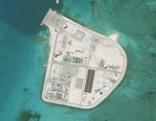
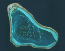
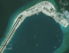
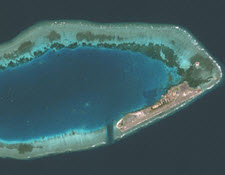
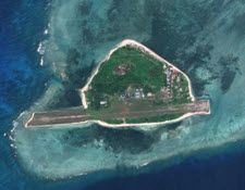
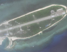
Skip to content

Sandra

Itu Aba Island

  • by

Itu Aba Island, along with nearby Zhongzhou reef, has been controlled by the Republic of China (Taiwan) since 1946. It is the largest of the naturally occurring features in the Spratly archipelago and the only one with natural freshwater supplies. Itu Aba has undergone roughly 32,000 square meters of land reclamation since August 2013 and is home to many notable facilities that have been built since the Republic of China took control. These include a hospital, weather stations, radar equipment, a solar-powered lighthouse, an airport, and airbase along with accompanying military and coast guard personnel.

Johnson Reef

  • by

Since China took control of Johnson Reef from Vietnam after a clash in 1988, the site has hosted a lone communications platform. Since March 2012, however, the reef has been expanded by 3.95 square kilometers following a major land reclamation campaign. Chinese construction crews have erected radar facilities, communications equipment, anti-aircraft weapons, and a helipad.

Minamiko-jima

  • by

On September 11, 2012, the government of Japanese Prime Minister Yoshihiko Noda nationalized three islands in the Senkaku/Diaoyu chain, which are claimed by China and Taiwan. Minamiko-jima is one of the three islands. The other two are Uotsuri-shimai and Kita-ko-shima.

Mischief Reef

  • by

Mischief Reef has been expanded by Chinese dredgers by 5.58 square kilometers since early 2015. The reef now hosts a large building powered by wind turbines and solar panels, and work is ongoing to create a 3,000-meter airstrip.

North Island

  • by

North Island lies approximately 12 kilometers (6.5 nautical miles) north of Woody Island in the Amphitrite Group of the Chinese-controlled Paracel Islands. The island is 300 kilometers (162 nautical miles) southeast of China’s Yulin/Longpo naval base. Satellite imagery taken in early 2016 showed the creation of a land bridge connecting North Island with its neighbor, Middle Island, just a few kilometers southeast. In March 2017, imagery revealed erosion of part of the bridge and new land cleared on North Island.

Code for Unplanned Encounters at Sea

  • by

The Code for Unplanned Encounters at Sea is a non-binding multilateral agreement standardizing safety protocols, basic communications, and basic maneuvering at sea for ships and aircraft. Over twenty countries adopted the code in 2014 at the Western Pacific Naval Symposium in Qingdao, China.

Scarborough Shoal

  • by

Located 120 nautical miles west of the northern Philippines, Scarborough Shoal is claimed by both Manila and Beijing. In 2012, a stand-off between Chinese and Philippine maritime law enforcement vessels was resolved through U.S. mediation. The China Coast Guard maintains a presence near the shoal and has reportedly prevented other nations’ fishing vessels from entering its enclosed lagoon.

Subi Reef

  • by

The size of Subi Reef has grown by 3.95 square kilometers since July 2014, when Chinese dredging ships began working on the maritime feature. The most notable addition to the reef is a runway of around 2,200 meters, which may be extended by around another 1,000 meters. This runway, first identified in a satellite image taken in April 2015, is the third Chinese combat-capable runway in the South China Sea.

Swallow Reef

  • by

Swallow Reef, a coral atoll occupied by Malaysia since 1983, has undergone nearly 283,000 square meters of land reclamation. Construction has been oncgoing and includes a naval station with an air-defense system, an airport with two aircraft hangers and a paved runway, a marine research facility, and a diving resort. The paved runway is over 1,300 meters long, allowing the operation of fighter jets in addition to transport and commercial airplanes.

Thitu Island

  • by

Thitu Island, the largest of the Philippine-controlled islands in the Spratly archipelago, has been enlarged by over 56,000 square meters since the Philippine government occupied the island in the 1970s. Military installations, mostly built around that time, include a military base, an unpaved and eroding runway as well as concrete bunkers. Approximately 200 residents live on the island and a small contingent of Philippine armed forces are stationed there.