The East China Sea has been described by some experts as a potential “flashpoint” of interstate conflict and great-power rivalry and a source of regional destabilization.[1] Much attention has focused on military activities in this maritime theater, primarily involving Japan, China, and South Korea. In contrast, this essay focuses on the complex maritime and sovereignty claims of Northeast Asian states in the East China Sea and unpacks the differing legal principles they use to support their claims in order to understand the enduring nature of the conflicts. These disputes are challenging precisely because they involve contests over both territorial sovereignty and maritime rights. The presence of different legal principles that states can draw on to defend their national interests makes these disputes more intractable, as states inconsistently use international legal principles to maximize their maritime entitlements.
Maritime Disputes
In the East China Sea, maritime and territorial disputes are distinct but interrelated. Territorial disputes emerge over ownership of the land features that dot the seas. Maritime disputes, on the other hand, relate to overlapping jurisdictional claims over maritime areas. Maritime zones such as an exclusive economic zone (EEZ) and a continental shelf provide sovereign rights but not full sovereignty (see Table 1). The primary legal mechanism for managing or resolving maritime disputes is the United Nations Convention on the Law of the Sea (UNCLOS), which has been signed and ratified by Japan, China, and South Korea, among other countries. However, while UNCLOS contains mechanisms for resolving maritime disputes, it does not apply to sovereignty disputes over territory. Sovereignty disputes are instead subject to a distinctive body of international law governing the acquisition of territory, which includes principles such as effective occupation, cessation, and conquest.
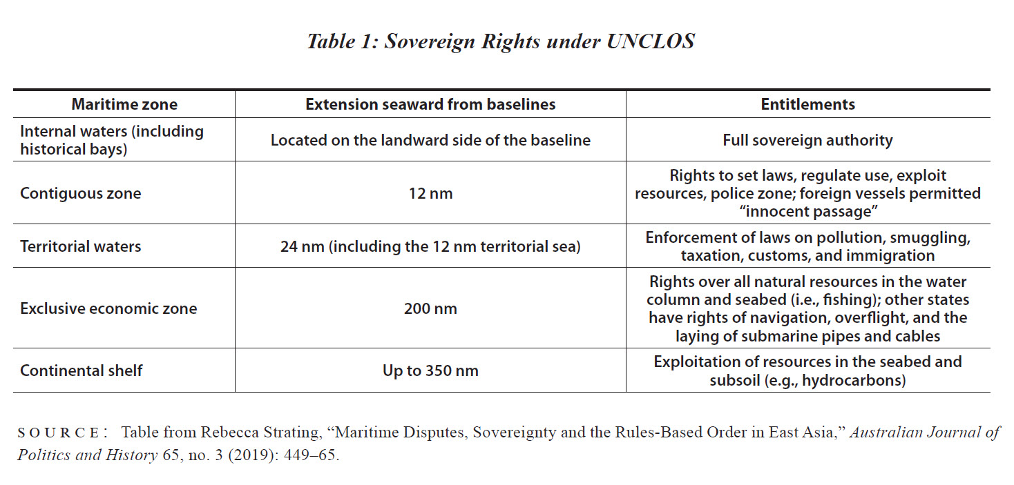
Eight of the nine maritime boundaries in Northeast Asia remain unsettled,[2] and these disputes endure partly because of geography. Northeast Asian countries are situated on closed or semi-enclosed seas, which means that states pursuing their full entitlements under UNCLOS often find their maritime claims overlapping with others. Moreover, the breadth of the seas on which these states are situated is less than 400 nautical miles (nm) wide. Under UNCLOS, states are entitled to an EEZ of up to 200 nm from their baselines. They may also be entitled to a continental shelf of up to 350 nm.
Problematically, there are different principles that states may draw on in order to delimit maritime boundaries. One is the principle of “natural prolongation” of the continental shelf, whereby states hold sovereign rights over territory that extends under the sea to the edge of a geomorphic continental shelf. The other is the use of the equidistant/median line, which since the third UNCLOS convention went into force in 1994 has become increasingly accepted as the basis for delimiting maritime boundaries, unless special circumstances warrant a different boundary line.
China’s, South Korea’s, and Japan’s EEZ and continental shelf claims overlap in the East China Sea. South Korea and China both claim continental shelves extending beyond 200 nm in the East China Sea. South Korea claims that the seabed and subsoil of the East China Sea form a continuous continental landmass extending from its coast. In its partial submission to the Commission on the Limits of the Continental Shelf (CLCS) for a portion of the outer limits of the continental shelf, South Korea renewed its claim in some parts up to 350 nm.[3] China also uses natural prolongation justifications in the East China Sea. In 2012, China submitted to the CLCS its claims that the outer limit of its continental shelf extends to the Okinawa Trough (beyond 200 nm from China’s baselines). Its claims were based on the principle of natural prolongation, which may permit a continental shelf to be extended beyond 200 nm.
The EEZ claims of China and Japan also overlap. Both states claim an EEZ of 200 nm from their coasts, yet the sea separating China and Japan spans only 360 nm. Whereas China claims a maritime boundary based on the natural extension of its continental shelf, Japan uses median line principles in determining the limits of its EEZ. Japan argues that the principle of natural prolongation is only applicable to the continental shelf, and only to the continental shelf beyond 200 nm.[4] This has produced an area in which maritime claims overlap.
Complicating the situation, the Chunxiao natural gas field was discovered near the overlapping EEZ in 1995. While the gas field lies on the Chinese side of the median EEZ border claimed by Japan (and contested by China), Japan argued that China should refrain from exploiting the field given its location. In 2011 a Chinese offshore oil firm confirmed that it had been producing oil from the disputed gas field, although China has stopped short of drilling within Japan’s claimed EEZ.[5]
Maritime disputes take on greater significance when natural resources are in play, such as potentially lucrative stocks of fish or hydrocarbon deposits. Mixed disputes involving both maritime and territorial aspects can also come to symbolize larger contests over national identity and sovereignty. In the East China Sea, such disputes are further compounded by fraught histories of conquest and domination.
Islands, Rocks, and Reefs
Further compounding Northeast Asia’s complex maritime geography is the presence of disputed land features, the ownership or classification of which can affect maritime claims. An island, for example, may generate the full suite of maritime entitlements, including up to a 200 nm EEZ and a continental shelf. Rocks, by contrast, are only entitled to a 12 nm territorial zone and are thus unable to generate EEZ or continental shelf claims. Reflecting their territorial nature, these sovereignty disputes are subject to historical grievances and the symbolic politics of national identity, which contributes to their intractability.
The 1951 San Francisco Peace Treaty was supposed to settle the issue of who owned the array of islands occupied by Japan during World War II. While Article 2 (6) officially renounced Japan’s rights to the Spratly and Paracel Islands in the South China Sea, the ambiguity of ownership of land features has contributed to territorial disputes in the East China Sea, including over Dokdo/Takeshima (administered by South Korea and claimed by Japan) and Senkaku/Diaoyu (administered by Japan and claimed by China).
Dokdo/Takeshima. The final text of the San Francisco Treaty did not list Dokdo/Takeshima as one of the territories to be returned to South Korea following World War II, despite its consideration in negotiations. In terms of de facto control, however, South Korea has asserted effective control of the features, and successive governments have presented this as a key element of the restoration of Korean sovereignty.
There are maritime implications of whether this feature is considered an island or a rock, and consequently whether an EEZ may be generated from baselines around it. While Japan claims that the features are an island, South Korea argues that the baselines are not entitled to an EEZ or continental shelf. South Korea has sought to establish sovereignty rather than demonstrate that the features are habitable for the purposes of claiming an EEZ. Japan, meanwhile, advocates taking the sovereignty issue to the International Court of Justice (ICJ). South Korea rejects this option on the grounds that it does not recognize a dispute, though its position is partly shaped by a belief that ICJ decisions have disadvantaged previously colonized states.
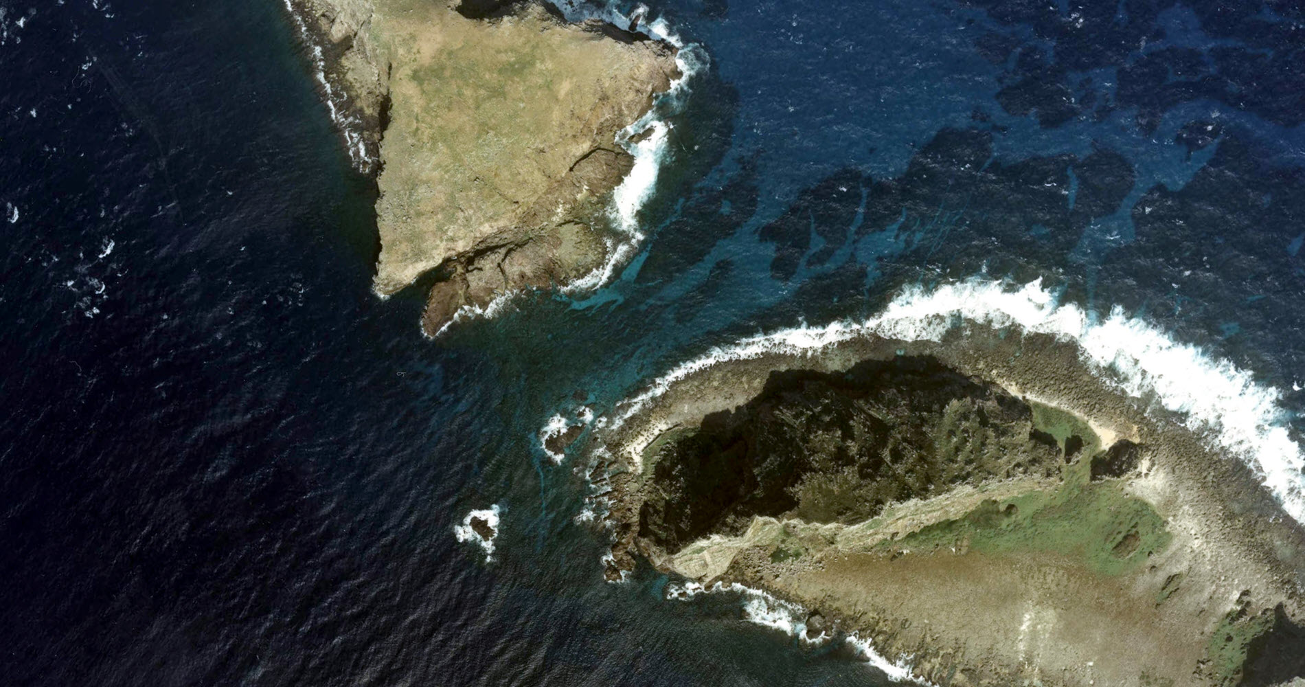
Senkaku/Diaoyu. By contrast, in the Senkaku/Diaoyu dispute it is Japan that has established effective occupation despite China’s claims to legitimate sovereignty of the islands. China began to assert its claims in the 1970s after the discovery of oil reserves, basing its position on a “historic rights” argument. Its protests of Japanese occupation of Senkaku/Diaoyu escalated after Tokyo nationalized the islands in 2012.
Japan denies that there is a dispute, reflecting its position as the effective occupier. It has also claimed that the disputed features are not rocks and so can generate an EEZ and continental shelf under UNCLOS. Japan is concerned about what it views as China’s violation of Japanese territorial waters around the features, as incursions by Chinese law-enforcement vessels increased after Japan nationalized the islands. These concerns intensified following China’s declaration of an air defense identification zone (ADIZ) in the East China Sea in November 2013, covering airspace over the Senkaku/Diaoyu Islands, Socotra Rock, and the outer limits of China’s continental shelf claims.
Socotra Rock. Some land features are not subject to sovereign acquisition under international law. A good example is Socotra Rock (named Ieodo by South Korea and Sunyan Jiao by China), which is a permanently submerged rock (or seamount) located between China and the Korean Peninsula in the Yellow Sea. Nearly five meters underwater at its highest peak, the rock has a surface area of just under four square kilometers.
Over the past two decades, disputes between China and South Korea over the status of this submerged feature have intensified. In 2003, South Korea constructed a scientific research station on Socotra Rock on the basis that it views the feature as part of its continental shelf. In response, China objected to the research station and rejected South Korea’s right to construct it without Chinese permission. China instead believes that the submerged feature falls within its EEZ and claimed jurisdiction over the feature in 2006.[6]
The dispute over Socotra Rock is not a territorial dispute in nature; rather, it is a maritime boundary issue. Both parties agree that Socotra should be classified as a submerged feature and is therefore not subject to sovereignty and has no rights to surrounding maritime zones, apart from a 500 meter safety zone. Instead, the question concerns within which state’s EEZ the rock falls or on which continental shelf it lies. The feature itself lies within an area of overlapping maritime claims between South Korea and China, almost exactly halfway between their claimed EEZ boundaries.[7] In the Yellow Sea, South Korea maintains that median line principles should apply, while China uses “equity” arguments to justify a different approach to maritime delimitation.[8]
This dispute is a consequence partly of unsettled maritime boundaries and partly of the gaps and overlapping principles of demarcation that exist in international law. Each state views Socotra Rock as part of its continental shelf based on different legal reasons. Contemporary international legal opinion has tended to favor the equidistance principle for delimiting boundaries in cases where the breadth of sea between adjacent states is less than 400 nm, unless there are special circumstances that require the line to be adjusted in order to achieve equity (as stipulated in Article 74 of UNCLOS).[9] Using this principle, South Korea claims that if a median line boundary were drawn in accordance with contemporary international law, the submerged feature would fall within its EEZ. It also argues that the reef falls on its continental shelf.
China claims that Socotra Rock falls under its jurisdiction based on the principle of natural prolongation. In the East China Sea, it uses this principle to defend a more advantageous demarcation of the continental shelf than would be secured using median line principles. China views the feature as part of its continental shelf and as lying within its EEZ. Yet, while UNCLOS provides for the natural prolongation principle under Article 76, this is qualified by Article 83, which mandates the achievement of an “equitable solution.” Natural prolongation thus appears increasingly outdated as the median line becomes favored in ICJ cases.
Why are these states concerned about a submerged rock? The dispute feeds into broader security concerns about maritime domains: the East China Sea is a theater of strategic anxiety for Northeast Asian states. The rock also falls within the ADIZs of China, South Korea, and Japan, although Japan makes no claim to the feature. The South Korean government expanded its ADIZ to encompass Socotra Rock just weeks after China’s announcement of its East China Sea ADIZ in 2013. South Korean officials had asked China to remove Socotra from its ADIZ, but China refused.[10] The reef may also be home to natural gas and mineral deposits.
Okinotorishima. In contrast to Socotra Rock, there are a number of disputes that relate to the classification of land features. One such example is Okinotorishima. The classification of land features has consequences for the legitimacy of maritime entitlements. Low-lying elevations are not subject to sovereignty; such land features are not entitled to a territorial sea, EEZ, or continental shelf under UNCLOS and can only generate a 500 meter safety zone.
Japan claims that the Okinotorishima atoll—located at the southernmost point of the Japanese archipelago—is significant enough to claim a 200 nm EEZ, constituting approximately 154,500 square miles, larger than Japan’s total land territory. Beijing does not recognize Tokyo’s EEZ claim. In 2004, Chinese officials began to describe Okinotorishima as “rocks” rather than “islands.” Some international lawyers, such as Jon Van Dyke, have agreed with China’s view that Okinotorishima meets the description of an “unhabitable” rock that “cannot sustain economic life of its own” under Article 121 (3) of UNCLOS.[11]
China wants rights to conduct seabed surveys to locate deepwater passages between Japan, Taiwan, and the Philippines for submarine use. In early 2019, Japan lodged an official protest after its coast guard spotted a Chinese government survey ship operating in the claimed EEZ around Okinotorishima without permission. Beijing maintains that Okinotorishima does not generate a continental shelf or EEZ, and therefore Japan’s authorization is not required. China is not alone in rejecting Japan’s interpretation. South Korea also views the atoll as rocks rather than islands and disputes Japan’s claim to an EEZ.[12]
Inconsistent Use of Legal Principles
A key issue is whether China, Japan, and South Korea can wind back their maritime claims in the East China Sea in order to negotiate solutions. The law is also not clear on principles for demarcating maritime boundaries. While the equidistance principle has become increasingly favored, its use is not mandatory under UNCLOS. Rather, the objective is to establish an equitable solution. In the Timor Sea dispute, for example, Australia and Timor-Leste ultimately negotiated a maritime boundary that did not entirely conform with the principle of either natural prolongation or equidistance.
One of the challenges, as discussed above, is that states pick and choose legal principles to suit their own interests in a specific dispute or maritime geography. For example, South Korea applies equidistance in the Yellow Sea but natural prolongation in the East China Sea. In the Socotra Rock dispute, it claims an EEZ based on median line principles. China also applies legal principles inconsistently, applying natural prolongation in the East China Sea and Yellow Sea but equidistance in the Bay of Korea.[13]
There are also different principles for determining EEZ and continental shelf claims, although these are often collapsed together—such as in Japan’s argument that the EEZ and continental shelf necessarily align in the East China Sea. China’s natural prolongation argument is viewed as conflicting with the legal principle that maritime boundaries should be delimited according to principles of equidistance. China has also apparently attempted to use history in order to determine its sovereign rights in the East China Sea. While it has become the trend for states to prefer a single maritime boundary encompassing both an EEZ and continental shelf, states may instead agree to a dual boundary with different borders for different zones. There are reportedly Korean scholars who believe that in the Yellow Sea dispute China may seek to delimit the continental shelf in accordance with the natural prolongation principle, while agreeing to use the median principle in delimiting the EEZ.[14]
Northeast Asian states have also distorted legal principles to their advantage, including by drawing straight baselines along their coasts in ways that others view as invalid under international law.[15] The U.S. Navy, for instance, conducted freedom of navigation operations in 1999, 2010, 2012, and 2016 to protest what it viewed as Japan’s excessive maritime claim emerging from the use of straight baselines. It also protested South Korea’s straight baseline claims in 1999, 2014, and 2016.[16]
Conclusion
The multifaceted disputes between Japan, China, and South Korea in the East China Sea have strategic implications for the region as the states seek to defend and justify their claims and interests. Part of the reason that these disputes are so difficult to resolve is they involve contests over both territorial sovereignty and maritime rights. They thus encompass disagreements about which state owns the land features, how those land features should be classified, and what principles should be used for delimiting maritime boundaries. These disagreements are to some extent enabled by the different legal principles—in both law of the sea and the acquisition of territory—that states can apply to defend their interests. Another factor is inconsistent attitudes toward the use of international courts in resolving these disputes.
Whether the maritime and territorial disputes in the East China Sea will be resolved is ultimately a question of political will. As maritime claims become increasingly linked to sovereignty, security, and historical grievance, it becomes more difficult for states to retreat from their claims.
Bec Strating is Executive Director of La Trobe Asia at La Trobe University.
Download a pdf version of this analysis piece here.
ENDNOTES
[1] See, for example, Todd Hall, “More Significance Than Value: Explaining Developments in the Sino-Japanese Contest over the Senkaku/Diaoyu Islands,” Texas National Security Review 2, no. 4 (2019): 11–37; Brendan Taylor, The Four Flashpoints: How Asia Goes to War (Melbourne: La Trobe University Press, 2018); and Zack Cooper, “Flashpoint East China Sea: Potential Shocks,” Asia Maritime Transparency Initiative, April 27, 2018.
[2] Suk Kyoon Kim, Maritime Disputes in Northeast Asia (Leiden: Brill Nijhoff, 2017), 51.
[3] Republic of Korea, “Partial Submission to the Commission on the Limits of the Continental Shelf Pursuant to Article 76 Paragraph 8 of the United Nations Convention on the Law of the Sea,” December 2012, 7–9.
[4] Kim, Maritime Disputes in Northeast Asia, 67.
[5] Yoichiro Sato, “Explained: China’s Rivalry with Japan in the East China Sea,” National Interest, September 16, 2020.
[6] For a more comprehensive overview, see Senan Fox, China, South Korea, and the Socotra Rock Dispute: A Submerged Rock and Its Destabilising Potential (Singapore: Palgrave Macmillan, 2019), 2.
[7] Fox, China, South Korea and the Socotra Rock Dispute, 2.
[8] Seokwoo Lee and Clive Schofield, “The Law of the Sea and South Korea: The Challenges of Maritime Boundary Delimitation in the Yellow Sea,” National Bureau of Asian Research, Maritime Awareness Project, April 23, 2020, https://www.nbr.org/publication/the-law-of-the-sea-and-south-korea-the-challenges-of-maritime-boundary-delimitation-in-the-yellow-sea.
[9] See, for example, International Court of Justice, Continental Shelf (Libyan Arab Jamahiriya/Malta) Judgment, June 3, 1985.
[10] Lily Kuo, “Will a Tiny, Submerged Rock Spark a New Crisis in the East China Sea?” Atlantic, December 9, 2013, https://www.theatlantic.com/china/archive/2013/12/will-a-tiny-submerged-rock-spark-a-new-crisis-in-the-east-china-sea/282155.
[11] See Yukie Yoshikawa, “The U.S.-Japan-China Mistrust Spiral and Okinotorishima,” Asia-Pacific Journal 5, no. 10 (2007): 2.
[12] Commission on the Limits of the Continental Shelf, “Outer Limits of the Continental Shelf Beyond 200 Nautical Miles from the Baselines: Submissions to the Commission: Submission by Japan,” 2020, https://www.un.org/Depts/los/clcs_new/submissions_files/submission_jpn.htm.
[13] Kim, Maritime Disputes in Northeast Asia, 56.
[14] Kim, Maritime Disputes in Northeast Asia, 56.
[15] Lee and Schofield, “The Law of the Sea and South Korea.”
[16] Annual freedom of navigation reports are available from the U.S. Department of Defense at https://policy.defense.gov/ousdp-offices/fon.
Photo Credit: Aerial Photo of Kitakojima and Minamikojima of Senkaku Islands. Made based on [https://mapps.gsi.go.jp/maplibSearch.do#1 National Land Image Information (Color Aerial Photographs)], Ministry of Land, Infrastructure, Transport and Tourism.